
Who is he?
An italian architect and “urban change agent”[1] who divides his time between Carlo Ratti Associati, the innovation and design studio he runs from Torino, and SENSEable City Lab, the research laboratory he leads out of the Massachusetts Institute of Technology, Boston. Ratti’s design and research work overlap significantly, both focussing on the transformative effect of new technologies on our built environment and daily lives.[2] The scope of his projects is incredibly wide, ranging from drone-based wayfinding to experimental furniture to citywide data mining.
Ratti was in Melbourne last month for a week of programs courtesy of the International Specialised Skills Institute. We attended the lunchtime seminar he presented at the University of Melbourne entitled, Decalogue for a [smart] SENSEable city. It was hosted in conjunction by the Faculty of Architecture, Building and Planning and the Melbourne Sustainable Society Institute.
What did we think?
Ratti began his seminar by quoting controversial American activist, George Gilder, who in 1995 claimed that “cities are leftover baggage of the industrial era… We are headed for the death of cities.” More moderately, fellow MIT scholar, Nicholas Negroponte, wrote in 1996 that “the post-information age will remove the limitations of geography. Digital living will include less and less dependence on being in a specific place at a specific time.”[3] Far from the death of cities however, Ratti observed that the past twenty years have instead witnessed their unparalleled prosperity. Global urbanisation is more widespread now than at any other time in history, with just over half of the world’s 7.1 billion population living in urban areas.[4]
Cities are thriving, but so is the penetration of digital technology into their fabric. “The digital revolution did not end up killing our cities, but neither did it leave them unaffected. A layer of networked digital elements has blanketed our environment, blending bits and atoms together in a seamless way.”[5] Evidence of this physical and digital conversion – the cyberphysical – is everywhere: from the 4 billion smartphones in circulation globally and the infiltration of social media into daily work habits, to the proliferation of remotely controlled security systems and transport infrastructure.
For Ratti, the exciting extrapolation of this process is our ability to use digital technology to learn from cities in order to improve them. Many of his projects involve crowdsourcing tiny fragments of data that are in themselves meaningless but when gathered together form very large sets of useful intelligence. He seeks to convert the city into a realtime control system, with inbuilt feedback loops that improve its economic, social and environmental sustainability. A difficult undertaking with a simple justification: while the physical layers of the city – roads, buildings, services – are expensive to build and respond slowly to change, the digital layers are cheap to implement and able to evolve very quickly to changing circumstances. In essence, Ratti wants the digital to allow us to better use what we already have of the physical.
Ratti structured his presentation around a series of diverse themes of urban engagement, including Smart phone smart city, i-Mobility, New universities, and Living together. The projects employed a compelling cocktail of skill sets, involving among others architectural design, graphic design, algorithmic computing, electrical engineering and web app development. Intervening in the emerging overlap between the physical and digital space of the city, they convincingly capture Ratti’s inexhaustible inventiveness and hunger for urban change.
Though Ratti covered a lot of ground during his hour-long seminar, we will focus here on three projects only, the ones that struck us as most clearly demonstrating his multi-disciplinary approach to urban problem solving.
 170 million annual taxi trips in New York City
 Journey from West 15th to East 54th Street
HubCab
www.hubcab.org
Project video via YouTube
i-Mobility
2014
HubCab is an interactive visualisation that allows users to explore every taxi trip taken within the City of New York in a year: a network of journeys that leave no lasting trace but nevertheless stitch the whole city together. Like many of SENSEable City Lab’s projects, the seduction of the visualisation masks an extraordinary backend algorithm processing vast quantities of information. According to the HubCab website, the basis of the project is “a data set of over 170 million taxi trips of all 13,500 medallion taxis in New York City in 2011. The data set contains GPS coordinates of all pick up and drop off points and corresponding times.”[6]
Employing an efficiency concept developed by Ratti’s team, shareability networks, the data set is analysed for potential redundancies i.e. whether a taxi trip travelling from point A to point B can be combined with a second trip travelling from point C to point D, thereby eliminating one trip entirely. When we click on a nominal trip, say from West 15th to East 54th Street (see above image), we can see that it forms part of a route with annual savings of $3.1m, 1.6m kilometres and 445,000kg of CO2. Ratti explained that employing shareability networks within a large, dense city like New York has the capacity to reduce the number of taxi trips in a year by a staggering 40%.

Map of Singapore where the scale is not measured in kilometres but travel time

Maps of central Singapore comparing mobile phone usage on typical days (left) and during the Singapore Grand Prix (right)
LIVE Singapore!
www.senseable.mit.edu/livesingapore/
Project video via YouTube
Public engagement 2.0
2010
LIVE Singapore! is an exercise in citywide mapping, establishing “a feedback loop between people, their actions, and the city.”[7] It gathers useful information like temperature, mobile phone usage, rainfall, taxi availability and traffic, and maps them with localised detail in realtime. The project team curated the mapping process, for instance juxtaposing taxi availability against rainfall, or mobile phone usage against a popular sporting event.
The selection of information types and process of juxtaposition reflect the true agenda of this project: “giving people visual and tangible access to realtime information about their city enables them to make their decisions in sync with their environment, with what is actually happening around them.”[8] If traffic congestion mapping can accurately tell us how long it will take to get somewhere, we can leave early enough to arrive on time. If we know that taxis are likely to get snapped up whenever it rains, we can take the train (or authorities can ensure greater supply).
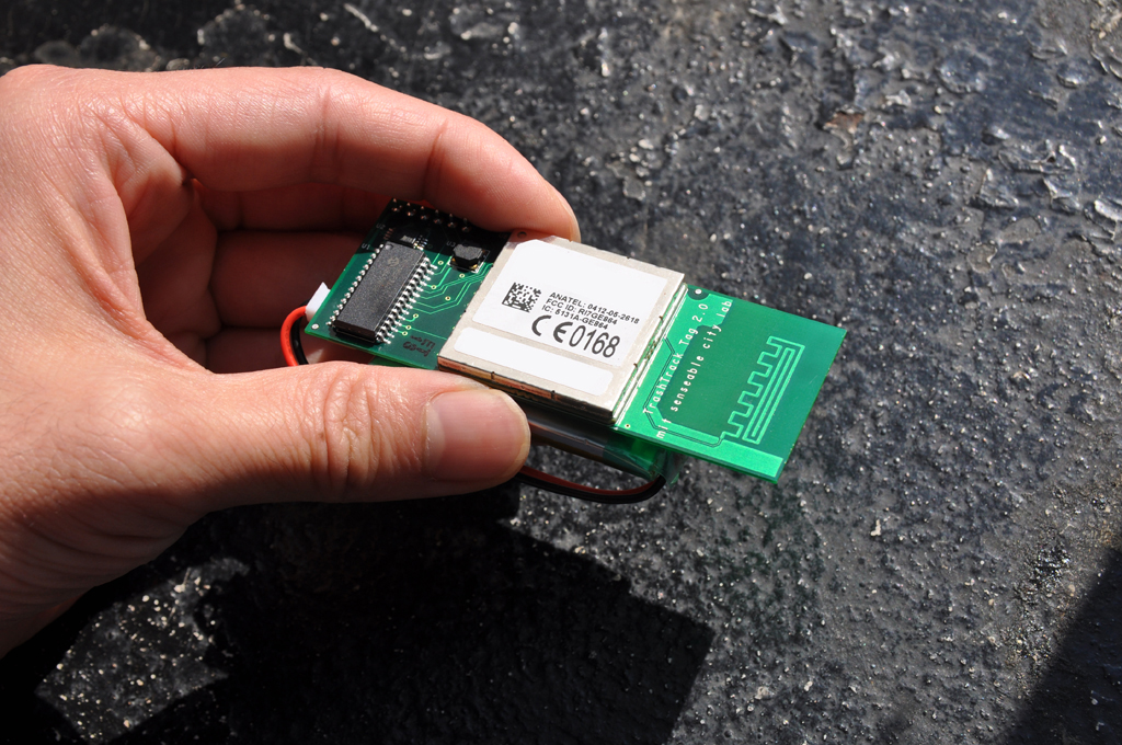 The tracking device used in TrashTrack
![]()
Movement of waste after two months
TrashTrack
www.senseable.mit.edu/trashtrack/
Project video via YouTube
Waste tracking
2009
This project asks the question, “why do we know so much about the supply chain and so little about the removal chain?”[9] It suggests that our interest in the supply of local produce does not extend to waste processes in large part due to our lack of awareness of them. TrashTrack seeks to highlight the movement of our waste products from household bins to final destinations.
Using a simplified version of technology found within mobile phones, Ratti’s team developed a tracking and broadcasting device that could be attached to pieces of waste. The team then invited 500 volunteers to tag regular pieces of household rubbish, 3,000 items in total ranging from old sneakers, to empty cans, banana peels and dead batteries. Once the volunteers went home and threw out their tagged waste items, the tags started reporting their locations and establishing tracking vectors of their movement.
The tags, or smart dust as Ratti referred to them, established a network of tiny locatable electromechanical systems. The video of the mapping process is astounding: items of waste found their way from Seattle to every corner of the United States, in the case of some alkaline batteries not coming to a rest for two months.
What did we learn?
To understand Ratti’s work, we must consider the way he views the major forces affecting contemporary urban environments. The rapid growth in global urbanisation is his first and perhaps most important influence: Ratti does not deny the decentralising tendencies of digital technology, but attributes the city’s survival despite these tendencies to our deep need for social contact: people want to live together. His works are inherently social, interested in enhancing the connections between people and their environments. Rather than permitting digital technologies to alienate the inhabitants of a city, he wants to empower them with new and unprecedented control.
Second, and essentially the core area of Ratti’s interventions, is the aforementioned and ever-expanding blanket of networked digital elements. He is impatient with the slowness of hard infrastructure, far more interested in the opportunities presented by new digital technologies: data, networks, connections and apps that have the power to reach and affect millions of people at a time. He reasons that a city is not such a big place nor such a mysterious creature to understand, not when millions of people are already walking around in it, already absorbing and transmitting data about their environments.
For us, we are most impressed with the clear DNA of Ratti’s projects. They tackle issues of environmental sustainability, quality of life, resource use, cultural engagement and social spaces. If these questions seem familiar it’s because they are: they’re the same questions architects face. What the architecture profession traditionally addresses via urban and building design, Ratti addresses with digital, scaleable technologies. His is an exciting new world, one where the practice of architecture retains its worldview, but expands to encompass whatever tools and skills are necessary to get the job done.
This thinking has been recently manifested in a project not discussed by Ratti in his presentation but already receiving a lot of attention online and now available for pre-ordering, the Copenhagen Wheel. An electric motor that attaches to the rear wheel of a bicycle, it “transforms the bicycle into a hybrid e-bike that also provides feedback on pollution, traffic congestion and road conditions in realtime.”[10] This project is an exciting development within Ratti’s work, one that shifts his practice beyond demonstration into application. We look forward to seeing more of it.
Footnotes:
- Carlo Ratti in Melbourne; ArchitectureAU; 13th March 2014
- Studio synopsis; Carlo Ratti Associati; accessed 20th April 2014
- Nicholas Negroponte; Being Digital; Hodder and Stoughton; 1996
- In 2011, 52.1% of the world population lived in urban areas. By 2050, this is projected to grow to 67.2%. Source: World Population Prospects; Population Division of the Department of Economic and Social Affairs of the United Nations Secretariat; 2011
- Carlo Ratti; Digital Cities: ‘Sense-able’ urban design; Wired; 2nd October 2009
- Project description; HubCab; accessed 27th April 2014
- Project description; LIVE Singapore!; accessed 27th April 2014
- Ibid.
- Project description; TrashTrack; accessed 28th April 2014
- Project description; Copenhagen Wheel; accessed 29th April 2014
Image credits:
- Carlo Ratti. MIT Technology Review, author unknown.
- Annual taxi trips, for HubCab; SENSEable City Lab; MIT; New York City; 2014
- Journey from West 15th to East 54th Street, for HubCab; SENSEable City Lab; MIT; New York City; 2014
- Isochronic Singapore, for LIVE Singapore!; SENSEable City Lab; MIT; Singapore; 2010
- Formula One City, for LIVE Singapore!; SENSEable City Lab; MIT; Singapore; 2010
- Trash tag v2.0, the tracking device used in TrashTrack; SENSEable City Lab, MIT; Seattle; October 2009
- Trash tagging map, for TrashTrack; SENSEable City Lab, MIT; Seattle; October 2009
Leave a Reply